


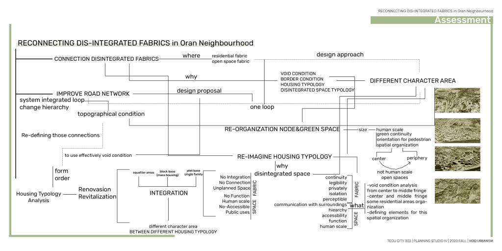

When defining disintegration in an algorithmic framework, I defined it as situations that different fabrics could not create when coming together. When this situation was first looked at in Ankara scale, I examined it in two sub-categories, fabric and space.
The situation where different fabrics cannot form a part-whole relationship while coming together is called disintegration. There is a disintegration problem in Ankara scale due to different void and border condition conditions. The way different fabrics come together defines a void and border condition. This described situation poses a problem for urban-scale residential areas. Remembering the Gestalt, I must say that different parts cannot come together. Furthermore, I can say that this has happened because the logic of housing production changes as you move from the center to the periphery. Since the changing production logic was made without considering the state of different fabrics, void and border conditions were created and defined the disintegration.
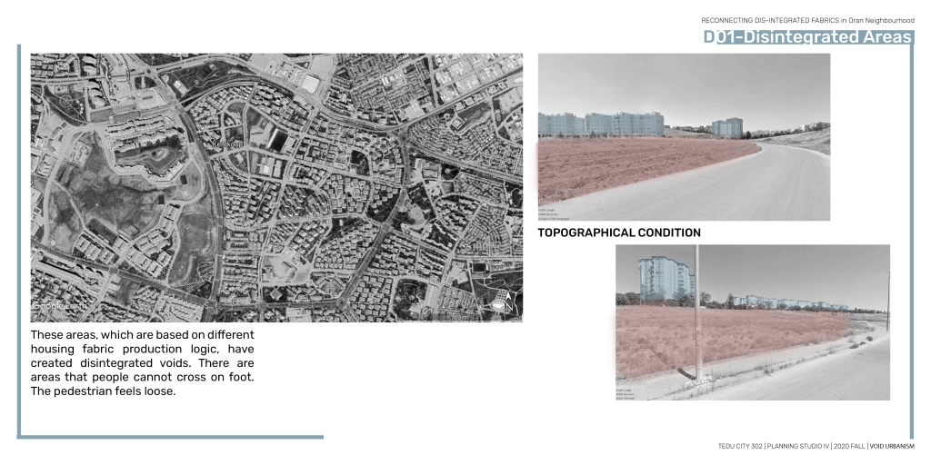
Looking at these examples, it contains more than one fabric in its own area. This situation caused breaks between fabrics. The disconnections were occasionally caused by the topography.These different cases have created different void conditions by creating spaces that cannot be crossed and walkable for pedestrians When I look at these examples at different scales, if I first talk about the situation in the North Ankara region; Depending on the topography in the area, the problem of an unsufficient circulation system comes to the fore. The spaces in the area are not human scale. When I look at these examples at different scales, if I talk about the situation in Kent-Koop and its surroundings in the second stage; Depending on the topography in the area, different void conditions come to the fore The last one is my own field of study. This area, which is formed by gated communities, squatters and apartment buildings, offers us an example of disintegration void. My workspace creates a disintegration problem by including all the situations I have mentioned in its scope.
To sum up, these regions have been evaluated with these concepts. In their reference, the study area has been selected.
The problem of disintegration fabric emerge as they came from the center towards the periphery.In my field, this is one of the examples on the periphery. Oran Neighborhood. Oran district is an area surrounded by Turan Güneş Boulevard and Konya Road. It contains different fabrics. There is Yıldız Mahallesi in the north. In the south, it is surrounded by the METU Forest.
When I look at the context of the area, I can say that it generally creates an area surrounded by housing and creates a void condition due to its topographical thresholds.
The reason for these areas created by the area is the current state of the topography.
This topography creates thresholds in the area and prevents pedestrian mobility.
The existing topographic situation has created such a void condition in the field.
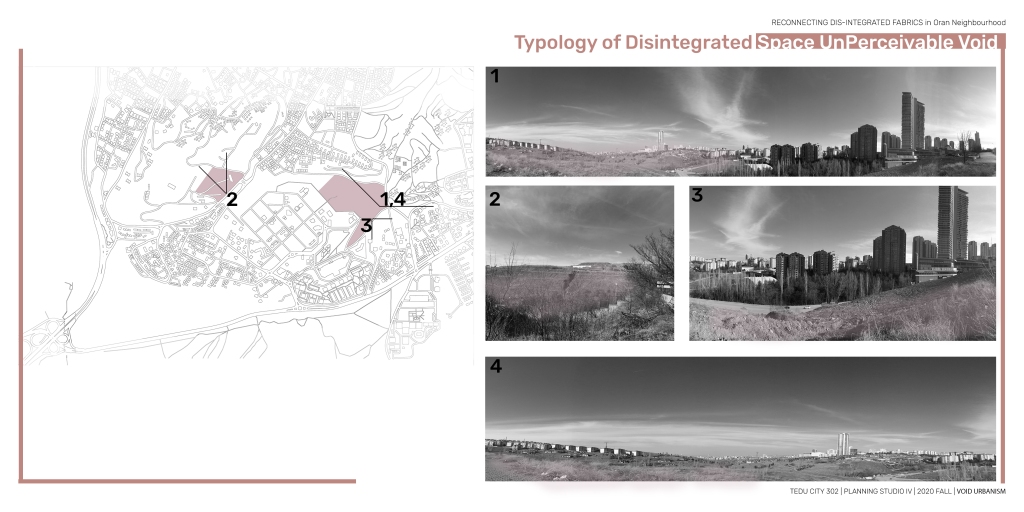
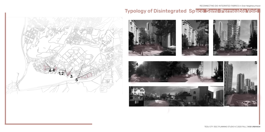
This situation, which is caused by the topography in the area, has classified the void condition for me. In my classification based on property and topography, I can say that the embassy area defines a void area originating from both topography and ownership. When I look at the area in general, it is possible to say that the southern part produces a more integrated void condition system, but it cannot be associated with the northern part.
This void condition caused the border condition. It is possible to say that the biggest problem in my field is the natural border, while basically separating the border condition into 2 stages.
The other factor affecting this border condition and void condition condition is different fabric. Accordingly, I divided it into 4 according to the form. In their reference, I removed 4 different sub-character fields in the field.
In this context, I classified it into three categories: detached, attached, block type. Accordingly, the axes and different connections in the lower diagram were conceptualized.
Looking at this sub-diagram with references, the axes emerging from these potential voids were identified and conceptualized.
These axes have clearly defined 4 program areas for us. If I remember my problem, it was the disintegrated void of these areas.
I made a photography work to define these areas. Since the topography of the area is important in the first context, I worked on the sloped concept. Photographing was carried out in areas with high slopes in the area. Looking at the Unsloped ones, I noticed that there is less in the field. I found that unsloped areas reduce the perceptibility of the field. Areas with less slope were more perceptible. As the slope increased, perceptibility decreased. The void condition condition was becoming more pronounced. Perceivable and unsloped areas provided semi-permeable areas, while these unperceivable areas generally provided permeable areas when I put them in the matrix, I realized that my detection was to determine a power line using the topography of the different sub character areas.
With the reference of this information, I proceeded to the synthesis stage. At this stage, which is before the design, first:
I determined lines of power with reference to the topography. I found that I can extract a loop from here. My goal was to continue the loop in the same contour. I gave a certain building limit, buildings that are not suitable for topography in the north of the area should be abandoned.
When I overlay it with this in the field with topo, I got such references layer by layer. I aimed to define new solutions for the areas by defining the first circulation with the loop that breaks together. This system, which is a reference for new construction and circulation, provides me with an input for design.
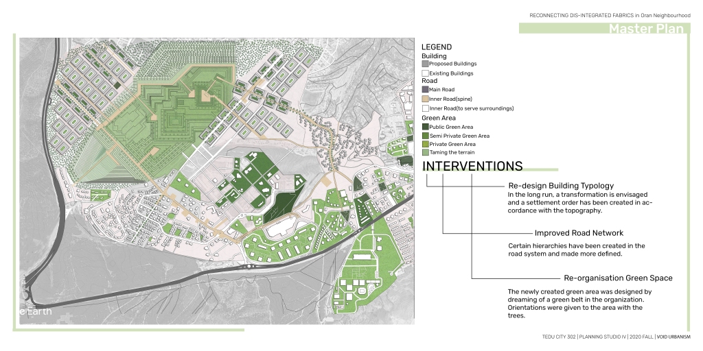
With reference to these inputs I have developed 3 basic strategies in my conceptual diagram in their reference. Connecting 4 different alt character fields Identifying power lines in accordance with the topography. Determining the structuring limit and filling the void according to this limit. Integration with green areas provided by taming terrain. According to these 3 basic strategies, I would connect different areas with a loop in the area. And I imagined how these areas would transform in the long run with sketches.
When I look at their strategies, I divided them into 3. I’ve added a green continuum. I tamed the land. In this way, I created certain focal points, which provided input from the spine to form an integrated system.
In this context, in the master plan I produced, I first focused on morphology, I developed a filling the void strategy with the question of whether a long-term transformation can occur in the squatters that were formed in the area and are currently in ruins, while these fabrics are settled in harmony with the topography. It is useful to define the loop.
Then, in the long run, I formulated a strategy to ask what would happen if there was a transformation in the north of the area. I aimed to create more qualified and more legible spaces in the courtyard buildings I produced by preserving the existing traces of the area.
With the lines coming from the topography, I spatialized the loop and determined its width as 15 meters and open to pedestrian vehicles. Loop connects different sub character fields to each other as a system.
In order to transform the loop into a legible system, a green area was arranged in the north, while an open area continuity was made, areas where pedestrians could move were presented in the western part of the area by taming the terrain intervention, and the paths that would connect the character areas were read by overcoming the topography. Locations and continuities have been added to different areas by giving directions with trees.
This whole system has defined the loop.
I looked at the layers of the master and this kind of change occurred in the first figure ground. It has been designed in a way that is more suitable for the topography. and I produced such a typology. It was emphasized that the structures created in the references of these concepts are more legible and the space setup is clearer. Settlements are arranged in accordance with the topography on the human scale.
In this context, a road system was developed in accordance with the movement and topography. and 4 types of road types were included in the produced matrix.
In this context, a circulation system was developed in accordance with the movement and topography. In this classification, according to the hierarchy, the movement of the pedestrian was provided in the spine in the first degree, and a movement system was considered in the axes of the spine in the second degree and the building island in the third degree.
offered spaces that pedestrians could use while gaining function at the rate of open space. typologically divided into three, and due to the disintegration problem Public, semi private, private. In this system, which is generally formed by increasing public use,
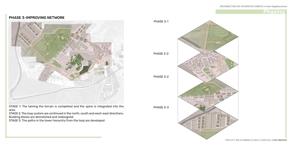
In the phasing work in the field, the spine will be in the first place. It will take place in 4 stages. First, the land spine will be tamed and the spine will be read, then the spine will be supported in the south of the area, and the spine will be completed with the long-term transformation in the north. In the second phase of phasing, the buildings that will transform in the long run are phased out. Divided three stages In Phase 3, the simultaneous mobility system will be improved depending on the others. In this system, which takes place in 3 stages, the first spine will be designed, followed by the north-south axis, and the extensions of the spine will be designed last.
To sum up, While integrating the dis-integration problem, which increases due to the housing fabric that differentiates from the center towards the periphery, with a loop in harmony with the topography of the area, I make the area more legible with production in certain typologies in the long run.
