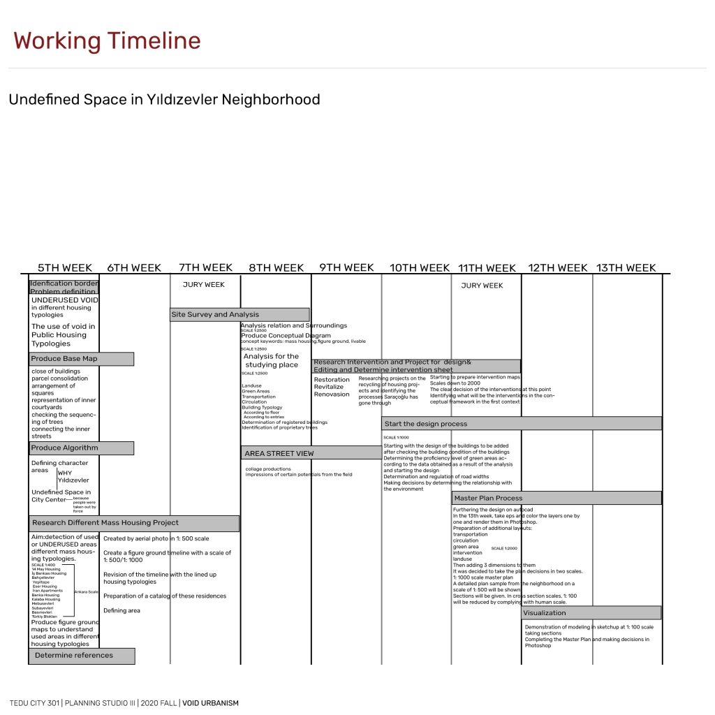

When I first started this process in the context of Ankara, I examined housing projects that can establish an open space relationship and present successful examples within it. Therefore, conceptually I aim to show you two different void conditions of the houses produced in two different zoning conditions in my work at Ankara scale. Spatial stratification and hierarchy are very good in these projects based on parcels. However, the land-right constructions brought by the following years have dispersed the spatial cascade.
With the dispersion of the spatial cascade, I noticed that there are undefined,non perception non-permeable housing projects in a visual context. When each project designs its own area and does not look outside, areas that I define as undefined space occur. In this context, I want to proceed with examples:
These lines represent the open space cascades in the space and the areas defined as defined. I see every example here as potential for my project. For example, İŞBANK blocks are located in a place where the spatial cascade has a strong relationship between high and open and closed areas.
But my problem area in the south has defined undefined spaces due to topographical thresholds with a few major cooperatives. If I look at other axes, for example, when designing SUBAYEVLERİ, it was designed as a residential place and it was aimed to offer people a place full of social facilities. The place, which is also like this today, describes this cascade from power lines.
If we look at the plot-based areas, they are spaces that are disconnected with their surroundings, only establishing a relationship with themselves, but with low perceptibility orientation. THEREFORE, IF I WOULD SAY MY CONCEPTUAL FRAMEWORK: DIFFERENT ZONING SITUATIONS(imar durumları) DIVIDE MY SELECTED AREA. THE FIELD BECOMES A TRANSITION ZONE WHILE CREATING A POTENTIAL AREA IN ITS NORTH AND SOUTH. I WANT TO RE IMAGINE THESE UNDEFINED SPACES IN THE NEXT STAGE.
Yes, in order to understand to my working area, I created an algorithm. As I said, the main problem of this area is that the open spaces between the residences cannot establish a relationship and these disconnections arise from topographical thresholds and sometimes from ownership status. These have undefined the area. I can say that it has also decreased its permeability in places.
ADDITIONALLY,I SHOULD SAY THAT Yıldızevler Neighborhood is bordered by Dikmen Valley Park on the west and void areas inside. These areas have become undefined. How is the transition between the inner part of this neighborhood and its surroundings and how is the interaction of these void areas established with the references of the housing typology of İşbank in the north?
If I say certain determinations about the area, the modal point of the south axis is Çankaya Villa and its surroundings. Since the city is moving south, slums first started here between 1950 and 1980. It used to belong to Mühye Village. For the population stuck in the bowl form topography of the city in the 1970s, it is the closest external location to the infrastructure and prestige areas.
In this context, During the process I created a basemap, I visualized some data. The green field setup and circulation scheme of the area is strong, but it is beginning to be a problem in the context of topographic threshold orientation. And as you can see in figure ground, there are “voids” that are extremely large in terms of area. Here, I wanted to show you the areas that better explain the topography of the area with the photography technique and are sometimes undefined.
Finally, I created problems and potentials to better understand the field with concepts. And I put some sections of these. It also brings potential to us from place to place. But the spatial fiction that it brings potential remains in the north of the field. There are spatial disconnections in the interior of the area. And a natural border was formed with Dikmen valley. When we experience the problem of physical permeability when we want to cross a single valley, visual permeability is very low. Its low visual permeability also affects perception and creates serious problems for the area.
If I will collect it for the last time, after looking at the void condition in different zoning conditions in my upper conceptual framework and doing its analysis, I chose this area and my goal in the area is to re-imagine the spaces I define as undefined space and effectively bring the people living there.